


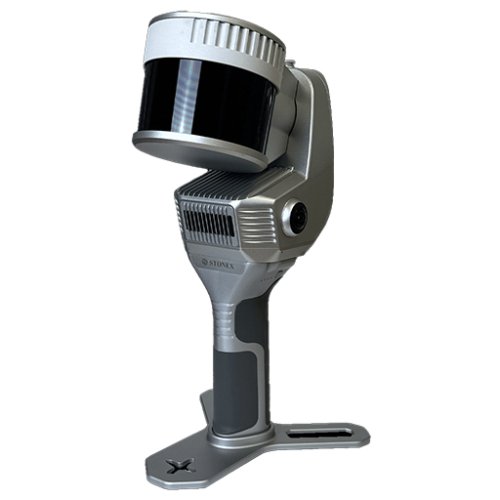
NEW Stonex X200GO SLAM Handheld Laser Scanner
The X200GO is the latest generation system based on the SLAM technology, capable of covering any customer need. The range of up to 300 metres and a rotating head that maximises the coverage of the laser beam make it versatile for any environment. Equipped with 2 cameras and RTK receiver for real-time point cloud colouring and orientation. The two cameras provide navigable and measurable panoramic cameras superimposed on the 3D model. The system allows for the survey of static scans in X-Whizz mode, automatically aligned to the SLAM survey.The X200GO is the latest generation system based on the SLAM technology, capable of covering any customer need.
The range of up to 300 metres and a rotating head that maximises the coverage of the laser beam make it versatile for any environment. Equipped with 2 cameras and RTK receiver for real-time point cloud colouring and orientation.
The two cameras provide navigable and measurable panoramic cameras superimposed on the 3D model. The system allows for the survey of static scans in X-Whizz mode, automatically aligned to the SLAM survey.
Backpack, shoulders hook, car mount and holder for DJI M350 can complete the system.
FEATURES
X-WHIZZ MODE
X200GO merges mobile and stationary surveying. To the advantageous SLAM solution that allows you to survey large areas in a very short time, it combines a stationary mode to scan with higher resolution. Mount X200GO on a monopod and stand still in key areas for a few seconds. It is the perfect trade-off for those who need speed and detail in a mobile survey.
RAPIDITY AND REDUCED WORKLOAD
No more multiple scan station, just move around the scene to collect the entire 3D point cloud, without time-consuming cloud to cloud alignment.
REAL TIME RESULTS
The built-in visual camera makes the real time SLAM algorithm more stable, especially in weak structural textures environments. The data are ready to be used as soon as the survey is completed.
AUTOMATIC CONTROL POINT MEASUREMENT
When capturing data, X200GO is able to collect reference points too. They can be matched with known control points to georeference the scans.
INTEGRATED CAMERAS
Two 12Mpx cameras
HIGH PERFORMANCE COMPUTATION
Very efficient system for perfect data return
SPECIFICATION
Sensor Model
Hesai XT32M2X
Max Range
300 m
Min Range
0.5 m
Return number
3
Scanning Point Frequency
Single Ret.: 640.000 pts/s
Dual Ret.: 1.280.000 pts/s
Triple Ret.: 1.920.000 pts/s
Field of view
360 Degree x 270 Degree
Laser Class
1
Channels
32
Wavelength
905nm
COLOR CAMERA
N° of pixels
24 Mpx (2 cameras, 12 MPx each)
Diagonal FOV
210°
Focal length
1.26 mm
Resolution
4000x3000 px
Sensor size
1/2.3 inch
Pixel size
1.55 μm
GNSS RECEIVER
Satellites Signal
GPS L1 C/A/L2P(Y)/L2C/L5
GLONASS G1/G2
Galileo E1/E5A/E5B
BDS B1I/B2I/B3I
QZSS L1/L2/L5
DGPS (RMS)
Horizon 0.4 m 1 ppm
Vertical 0.8 m 1 ppm
RTK (RMS)
Horizon 0.8cm 1ppm
Vertical 1.5cm 1ppm
Speed accuracy (RMS)
0.03m/s
SYSTEM
Relative accuracy
Up to 6mm
Global accuracy
Up to 2cm
5cm on UAV platform1
Control point support
Ground & wall
Data storage
512GB SSD
Communication
Wi-fi, Bluetooth, USB type-c, Lemo connector
Operating mode
SLAM & X-Whizz modes, Real-time visualisation, colouring and orientation
Processing mode
Real-time processing Post-processing with GOpost
ELECTRICAL SPECIFICATION
Power consumption
26W
System supply voltage
20V
Operating time
1.2 h (single battery)
External power
USB type-c
Battery input voltage
5-20V
Battery output voltage
10.8V
Battery capacity
3000mAh
PHYSICAL SPECIFICATION
Weight
1.4 kg (without battery)
1.9 kg (with battery)
Size
403.6 mm x 173.8mm x 170mm
Operating temperature
-20°C to 50°C (-4°F to 122°F)
Operating humidity
<95%
Waterproof/Dustproof
IP54
INCLUDED :
Monopod
Backpack
Tablet Holder
Shoulders Hook
RTK
Also you can check product : NEW Stonex X70GO SLAM 3D Laser Scanner
Drone Mount
- Availability: 16 In Stock
- Model: X200GO
-
Brand:

