
3D Laser Scanner
In the world of design and modeling techniques, you may be familiar with the term 3D Laser Scanning. 3D Laser Scanning is included in NDT or non-destructive test technology which digitally captures the shape of physical objects such as buildings using laser light. 3D Laser Scanning creates point clouds of data from the surface of the scanned object.
In other words, 3D Laser Scanning is a way to accurately take the size and shape of a physical object and then enter it into a computer in 3D/3 dimensional form. 3D Laser Scanner is a tool capable of laser scanning.
3D Laser Scanner is a tool that can capture the shape of a physical object and then display it to a computer. The data that has been collected will be in 3D form which is useful for development or project needs.
3D Laser Scanner measures fine details and captures freeform shapes to quickly produce highly accurate point clouds. This tool is suitable for measuring and inspecting contoured surfaces and complex geometries that require large amounts of data for accuracy.
The X200GO is the latest generation system based on the SLAM technology, capable of covering any customer need. The range of up to 300 metres and a rotating head that maximises the coverage of the laser beam make it versatile for any environment. Equipped with 2 cameras and RTK receiver for real-time point cloud colouring and orientation. The two cameras provide navigable and measurable panoramic cameras superimposed on the 3D model. The system allows for the survey of static scans in X-Whizz mode, automatically aligned to the SLAM survey.

This powerful scanner allows easy and fast capture of 3D models indoor & outdoor eliminating the need of collecting tens of scans from various stations and of complex multi-cloud registrations. Just move around the scene with XH120 and see the point cloud growing as more data is added in real time. XH120 is an handheld 3D laser scanner based on STONEX SLAM technology. Boost your productivity reducing on site capturing time and post processing workload!

X120GO has an integrated structure design with a built-in control and storage system and built-in replaceable lithium batteries. Once pressed the start button, X120GO can start operations immediately, making data acquisition more efficient and convenient. X120GO can use GOapp to check and manage projects which will be updated and displayed synchronously. Real-time SLAM mapping and preview can be achieved via GOapp.

X100 is a small and compact terrestrial laser scanner that is quick and easy to use. Its multi-line lidar technology and ability to achieve complete coverage of the surrounding area enable it to calculate 3D models for a wide range of applications and scenarios, both outdoors and indoors.
The scanner comes with its own X100app field app, making it easy to control the device. Thanks to the scan converter, the data is compatible with Cube-3d and Stonex Reconstructor, as well as third-party software. The X100 is the perfect tool for quick topographic surveys, scans of building facades and data collection for floor plans; a quick 360° scan takes as few as 45 seconds.

X150 is a robust and easy-to-use scanner for quick surveys up to 150 m. The multi-line full dome Lidar technology allows computing 3D models for a wide range of applications. X150 comes with it’s own processing software and is also compatible with Stonex Cube-scan and Stonex Reconstructor software. A perfect tool for fast topographic grade surveys and indoor floor maps.

STONEX X300 is a 3D Laser Scanner designed to provide accurate data every time and for any project.
The ease of use, reliability, flexibility and price make X300 a highly competitive product, now further improved with new features. The X300 File Manager tool allows you to convert the data collected with the X300 Laser Scanner into Stonex Reconstructor file format or other standard formats. The files obtained can be used directly in third party software, such as CAD, forensic analysis or road accident analysis.

X70GO is a real-time 3D model reconstruction device which integrates inertial navigation module, high performance computer and storage system. It is equipped with a 360° rotating head, which, combined with the SLAM algorithm, generates high-precision point cloud data. A 12 MP visible-light camera provides texture information, while a visual camera guarantees stronger real time preview with GOapp. Mapping results are generated immediately inside the scanner, right after scanning: choose if you want to color them and improve their accuracy, postprocessing with GOpost software.

FJD Trion S1 3D Handheld LiDAR Scanner is the most powerful scanner for indoor and outdoor use. Equipped with 16 sensors, it can scan 320,000 points per second with an accuracy of 0.8-2 cm. Trion S1 Handheld LiDAR 3D Scanner captures high quality scans at epic speeds. Powered by world-leading SLAM algorithms, the Trion S1 can also capture, process and display accurate point clouds in real time on mobile terminals.

SLAM-empowered lightweight handheld laser scanner for easy reality capture. Scan environments as you walk and create 3D models, floor plans and BIM. With an internal grip battery, it allows for a more balanced weight distribution, which not only enhances the overall using experience but also conforms to ergonomic principles. Whether you are a seasoned laser scanning professional or just 3D-curious, a walk around the site with the P1 lets you digitize your environment quickly and accurately.

The ultimate mobile mapping solution, Your versatile tool to capture, process and understand the world around you.
Our most flexible scanner now available with real-time data previews. The ZEB Horizon RT allows you to track your progress as you scan. It is the ideal, easy-to-use tool to gain real-time insight into your scans and to see your point cloud being created as you walk.

The FARO FocusS70 is a high accuracy, short range scanner specifically designed for architecture, engineering, construction, product design and public safety-forensics professionals. FARO, the world’s most trusted source for 3D measurement and imaging solutions for factory metrology, product design, construction BIM/CIM, public safety-forensics and 3D machine vision applications, announces the release of the latest addition to the FARO® Focus Laser Scanner portfolio.

With a 10-times boost in maximum instantaneous scan speed and the full freedom and accuracy of a total station, Leica ScanStation 2 has lifted laser scanning to the next level.This speed and productivity boost builds on the already industry-leading versatility of the ScanStation™ class of laser scanner to make High-Definition Surveying™ (HDS™) profitable for even more as-built and topographic survey projects. Set includes the Scanstation itself with AC power supply / adapter cable, tripod mount and large shipping case. Target package with 6 tripods, 6 rectangular targets, two circular rotating targets, & various extensions poles in large rolling shipping case. Also included is two battery chargers and 4 batteries & cables for field use.

The ultra-portable Focus S 150 enables fast, straightforward and ultra-high accurate measurements of objects and buildings. Delivering realistic and true-to-detail scan results with a range of 150m per scan. Featuring a HDR 8MP Camera, /- 1mm range error. Use standalone or mount to manipulators / UAV / UGV.The Focus S 150 combines all benefits from FARO’s well-known Focus3D Laser Scanners with today’s most innovative features to perform laser scanning in both indoor and outdoor environments - truly mobile, fast and reliable.

Powered by GeoSLAM’s proven SLAM algorithm, Orbis and Orbis Premium are the next steps for industry professionals looking to quickly deliver highly accurate results, reduce user impact, and increase overall efficiency. Leverage the power of Flash Technology scanning capabilities — elevated by in-field cloud-connectivity with FARO Sphere® XG — and embark on a new journey to transform your projects with Orbis and Orbis Premium, the ultimate companions for modern scanning challenges.

The world’s most popular terrestrial laser scanner with ultra-high accuracy and ingress protection. The FocusS series is the latest addition to FARO’s popular, compact, lightweight and intuitive laser scanner product line. The devices of this series are the most forward-thinking laser scanners on the market, adding several customercentric features, such as Ingress Protection Rating (IP54), increased scanning accuracy and range, an internal accessory bay and a built-in on-site compensation routine.

FARO latest ultra-portable Focus S Laser Scanner enables you to capture fast, straightforward and accurate measurements of complex objects and buildings. The intuitive touch-screen of the Focus S models has been increased in size and clarity to deliver an extraordinary user experience. A built-in 8 mega-pixel, HDR-camera captures detailed imagery easily while providing a natural color overlay to the scan data in extreme lighting conditions. Familiar traits such as lightweight, small size, and a 4.5-hour battery runtime per charge make the Focus S Laser Scanner truly mobile for fast, secure, and reliable scanning.

The ultra-portable device enables fast, straight-forward and accurate measurements of indoor crime scenes, small-scale facades, complex structures, production and supply facilities and manageable accident scenes. Combining the highest-precision scanning technology with authentic mobility and ease-of-use, the new device offers reliability, flexibility, and real-time views of recorded data. The 3D scan data can easily be imported into all commonly used software solutions for architecture and construction, forensics and accident reconstruction or industrial manufacturing.

Galois is our next-generation, professional-grade 3D laser scanner, capable of scanning over 164,000 square feet of indoor and outdoor space. Galois harmonizes image performance with accurate and efficient capture to create immersive digital experiences like no other. The laser radar technology further enhances the precision of the products. It has been tested that the measurement error of the interior area of a 100 square meter house can be controlled within 0.4%.

From site to insights, Blink is a reality capture solution designed for simplicity and accessibility. It brings high-quality visualization and automated workflows into the hands of designers, builders, surveyors, operators, and public safety professionals, helping teams capture, view, and share data seamlessly, regardless of expertise. With Blink, anyone can take control of reality capture on-site and move projects to final delivery efficiently. This imaging laser scanner is designed with simplicity in mind, bringing automated insights, a visual-first approach, and an intuitive workflow to professionals across industries.

The Focus Premium provides exceptional capturing efficiency, data quality and accuracy for public safety professionals while offering data quality at faster scan speeds. It is capable of reducing on-scene scanning time by up to 50% using your regular settings. Meanwhile, faster loading and system response yields greater data management efficiency when paired with the new FARO Stream mobile app, a solution Focus Premium operators can use on-scene to take pre-registration scans. Flash Technology, a new scan mode accessed through Stream, is ideal for pre-incident planning, offering full-color scans that merge the data from a 360° panoramic image with a faster scan 3D point cloud.
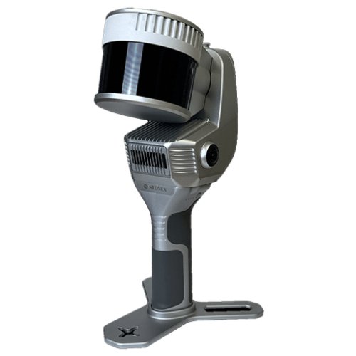
NEW Stonex X200GO SLAM Handheld Laser Scanner (X200GO)
The X200GO is the latest generation system based on the SLAM technology, capable of covering any customer need. The range of up to 300 metres and a rotating head that maximises the coverage of the laser beam make it versatile for any environment. Equipped with 2 cameras and RTK receiver for real-time point cloud colouring and orientation. The two cameras provide navigable and measurable panoramic cameras superimposed on the 3D model. The system allows for the survey of static scans in X-Whizz mode, automatically aligned to the SLAM survey.
NEW Stonex XH120 SLAM Handheld 3D Laser Scanner (Stonex XH120)
This powerful scanner allows easy and fast capture of 3D models indoor & outdoor eliminating the need of collecting tens of scans from various stations and of complex multi-cloud registrations. Just move around the scene with XH120 and see the point cloud growing as more data is added in real time. XH120 is an handheld 3D laser scanner based on STONEX SLAM technology. Boost your productivity reducing on site capturing time and post processing workload!
NEW Stonex X120GO SLAM 3D Laser Scanner (Stonex X120GO)
X120GO has an integrated structure design with a built-in control and storage system and built-in replaceable lithium batteries. Once pressed the start button, X120GO can start operations immediately, making data acquisition more efficient and convenient. X120GO can use GOapp to check and manage projects which will be updated and displayed synchronously. Real-time SLAM mapping and preview can be achieved via GOapp.
NEW Stonex X100 3D Laser Scanner (X100)
X100 is a small and compact terrestrial laser scanner that is quick and easy to use. Its multi-line lidar technology and ability to achieve complete coverage of the surrounding area enable it to calculate 3D models for a wide range of applications and scenarios, both outdoors and indoors.
The scanner comes with its own X100app field app, making it easy to control the device. Thanks to the scan converter, the data is compatible with Cube-3d and Stonex Reconstructor, as well as third-party software. The X100 is the perfect tool for quick topographic surveys, scans of building facades and data collection for floor plans; a quick 360° scan takes as few as 45 seconds.
NEW Stonex X150 3D Laser Scanner - High Accuracy (Stonex X150)
X150 is a robust and easy-to-use scanner for quick surveys up to 150 m. The multi-line full dome Lidar technology allows computing 3D models for a wide range of applications. X150 comes with it’s own processing software and is also compatible with Stonex Cube-scan and Stonex Reconstructor software. A perfect tool for fast topographic grade surveys and indoor floor maps.
NEW Stonex X300 3D Laser Scanner (X300)
STONEX X300 is a 3D Laser Scanner designed to provide accurate data every time and for any project.
The ease of use, reliability, flexibility and price make X300 a highly competitive product, now further improved with new features. The X300 File Manager tool allows you to convert the data collected with the X300 Laser Scanner into Stonex Reconstructor file format or other standard formats. The files obtained can be used directly in third party software, such as CAD, forensic analysis or road accident analysis.
NEW Stonex X70GO SLAM 3D Laser Scanner (Stonex X70GO)
X70GO is a real-time 3D model reconstruction device which integrates inertial navigation module, high performance computer and storage system. It is equipped with a 360° rotating head, which, combined with the SLAM algorithm, generates high-precision point cloud data. A 12 MP visible-light camera provides texture information, while a visual camera guarantees stronger real time preview with GOapp. Mapping results are generated immediately inside the scanner, right after scanning: choose if you want to color them and improve their accuracy, postprocessing with GOpost software.
NEW FJD Trion S1 3D Handheld LiDAR Scanner (FJD Trion S1)
FJD Trion S1 3D Handheld LiDAR Scanner is the most powerful scanner for indoor and outdoor use. Equipped with 16 sensors, it can scan 320,000 points per second with an accuracy of 0.8-2 cm. Trion S1 Handheld LiDAR 3D Scanner captures high quality scans at epic speeds. Powered by world-leading SLAM algorithms, the Trion S1 can also capture, process and display accurate point clouds in real time on mobile terminals.
NEW FJD Trion P1 3D Handheld LiDAR Scanner (FJD Trion P1)
SLAM-empowered lightweight handheld laser scanner for easy reality capture. Scan environments as you walk and create 3D models, floor plans and BIM. With an internal grip battery, it allows for a more balanced weight distribution, which not only enhances the overall using experience but also conforms to ergonomic principles. Whether you are a seasoned laser scanning professional or just 3D-curious, a walk around the site with the P1 lets you digitize your environment quickly and accurately.
USED GeoSlam Zeb Horizon 3D Mobile Laser Scanner (Zeb Horizon)

The ultimate mobile mapping solution, Your versatile tool to capture, process and understand the world around you.
Our most flexible scanner now available with real-time data previews. The ZEB Horizon RT allows you to track your progress as you scan. It is the ideal, easy-to-use tool to gain real-time insight into your scans and to see your point cloud being created as you walk.
USED Faro Focus S70 3D Laser Scanner - Calibrated 2022 (Focus S70)
The FARO FocusS70 is a high accuracy, short range scanner specifically designed for architecture, engineering, construction, product design and public safety-forensics professionals. FARO, the world’s most trusted source for 3D measurement and imaging solutions for factory metrology, product design, construction BIM/CIM, public safety-forensics and 3D machine vision applications, announces the release of the latest addition to the FARO® Focus Laser Scanner portfolio.
USED Leica ScanStation 2 HDS - 4050 Laser Scanner - Calibrated (ScanStation 2 HDS - 4050)
With a 10-times boost in maximum instantaneous scan speed and the full freedom and accuracy of a total station, Leica ScanStation 2 has lifted laser scanning to the next level.This speed and productivity boost builds on the already industry-leading versatility of the ScanStation™ class of laser scanner to make High-Definition Surveying™ (HDS™) profitable for even more as-built and topographic survey projects. Set includes the Scanstation itself with AC power supply / adapter cable, tripod mount and large shipping case. Target package with 6 tripods, 6 rectangular targets, two circular rotating targets, & various extensions poles in large rolling shipping case. Also included is two battery chargers and 4 batteries & cables for field use.
NEW Faro Focus S150 Laser Scanner (Focus S150)
The ultra-portable Focus S 150 enables fast, straightforward and ultra-high accurate measurements of objects and buildings. Delivering realistic and true-to-detail scan results with a range of 150m per scan. Featuring a HDR 8MP Camera, /- 1mm range error. Use standalone or mount to manipulators / UAV / UGV.The Focus S 150 combines all benefits from FARO’s well-known Focus3D Laser Scanners with today’s most innovative features to perform laser scanning in both indoor and outdoor environments - truly mobile, fast and reliable.
USED Faro Orbis Premium Mobile Laser Scanner - Calibrated (Orbis)
Powered by GeoSLAM’s proven SLAM algorithm, Orbis and Orbis Premium are the next steps for industry professionals looking to quickly deliver highly accurate results, reduce user impact, and increase overall efficiency. Leverage the power of Flash Technology scanning capabilities — elevated by in-field cloud-connectivity with FARO Sphere® XG — and embark on a new journey to transform your projects with Orbis and Orbis Premium, the ultimate companions for modern scanning challenges.
USED Faro Focus S350 Terrestrial 3D Laser Scanner - Calibrated (Focus S350)
The world’s most popular terrestrial laser scanner with ultra-high accuracy and ingress protection. The FocusS series is the latest addition to FARO’s popular, compact, lightweight and intuitive laser scanner product line. The devices of this series are the most forward-thinking laser scanners on the market, adding several customercentric features, such as Ingress Protection Rating (IP54), increased scanning accuracy and range, an internal accessory bay and a built-in on-site compensation routine.
USED Faro Focus S150 3D Laser Scanner - Fresh Calibrated (Focus S150)
FARO latest ultra-portable Focus S Laser Scanner enables you to capture fast, straightforward and accurate measurements of complex objects and buildings. The intuitive touch-screen of the Focus S models has been increased in size and clarity to deliver an extraordinary user experience. A built-in 8 mega-pixel, HDR-camera captures detailed imagery easily while providing a natural color overlay to the scan data in extreme lighting conditions. Familiar traits such as lightweight, small size, and a 4.5-hour battery runtime per charge make the Focus S Laser Scanner truly mobile for fast, secure, and reliable scanning.
USED Faro Focus M70 3D Laser Scanner With Gitzo Tripod - Calibrated (Focus M70)
The ultra-portable device enables fast, straight-forward and accurate measurements of indoor crime scenes, small-scale facades, complex structures, production and supply facilities and manageable accident scenes. Combining the highest-precision scanning technology with authentic mobility and ease-of-use, the new device offers reliability, flexibility, and real-time views of recorded data. The 3D scan data can easily be imported into all commonly used software solutions for architecture and construction, forensics and accident reconstruction or industrial manufacturing.
NEW REALSEE Galois M2 3D Lidar Camera (REALSEE Galois M2)
Galois is our next-generation, professional-grade 3D laser scanner, capable of scanning over 164,000 square feet of indoor and outdoor space. Galois harmonizes image performance with accurate and efficient capture to create immersive digital experiences like no other. The laser radar technology further enhances the precision of the products. It has been tested that the measurement error of the interior area of a 100 square meter house can be controlled within 0.4%.
Used Faro Blink Imaging Laser Scanner (Faro Blink)
From site to insights, Blink is a reality capture solution designed for simplicity and accessibility. It brings high-quality visualization and automated workflows into the hands of designers, builders, surveyors, operators, and public safety professionals, helping teams capture, view, and share data seamlessly, regardless of expertise. With Blink, anyone can take control of reality capture on-site and move projects to final delivery efficiently. This imaging laser scanner is designed with simplicity in mind, bringing automated insights, a visual-first approach, and an intuitive workflow to professionals across industries.
NEW Faro Focus Premium 350 Laser Scanner (Focus Premium 350)
The Focus Premium provides exceptional capturing efficiency, data quality and accuracy for public safety professionals while offering data quality at faster scan speeds. It is capable of reducing on-scene scanning time by up to 50% using your regular settings. Meanwhile, faster loading and system response yields greater data management efficiency when paired with the new FARO Stream mobile app, a solution Focus Premium operators can use on-scene to take pre-registration scans. Flash Technology, a new scan mode accessed through Stream, is ideal for pre-incident planning, offering full-color scans that merge the data from a 360° panoramic image with a faster scan 3D point cloud.


